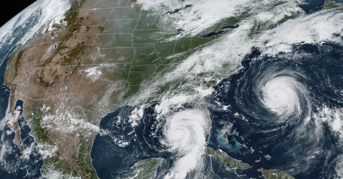
Earlier this week, mission control instructed the International Space Station to redirect its cameras towards the Gulf of Mexico. The stunning sight of white clouds against the backdrop of the blue oceans and space indicated the looming presence of Hurricane Idalia off the Florida coast. From this unique vantage point, it was difficult to determine the full extent of the havoc Idalia would wreak, including the historic storm surges and widespread flooding across Florida, Georgia, and the Carolinas. However, what was evident was the unusual conditions under which the storm had formed.
This hurricane season has been marked by the convergence of two opposing trends that are influencing storm dynamics. The planet is currently experiencing an El Niño year, a natural climate phenomenon that typically suppresses hurricane activity in the Atlantic basin. As a result, the Atlantic hurricane season has been relatively calm this year due to these conditions.
However, we are also in the midst of a record-breaking hot year that is on track to be the warmest ever recorded. This summer, Earth’s oceans have reached temperatures unprecedented in modern history. The Gulf of Mexico, in particular, has experienced surreal levels of heat. Climate experts attribute these extremely high temperatures to both El Niño events and climate change. Dillon Amaya, a research scientist at the National Oceanic and Atmospheric Administration’s Physical Sciences Laboratory, explained that climate change intensifies marine heat waves associated with El Niño. These hot seawaters, in turn, supercharge the formation and intensification of hurricanes by warming the air above the ocean’s surface.
This year is unlike anything we have seen before, as a combination of extraordinary ocean temperatures and El Niño conditions create an unpredictable hurricane season. The case of Hurricane Idalia demonstrates how warmer temperatures can have a profound impact. Idalia rapidly escalated from a Category 1 to a Category 4 hurricane in just one day, highlighting the role of hot oceans in intensifying storms in a matter of hours. While climate experts caution against drawing conclusions about an entire season based on one hurricane, it is clear that climate change has warmed our oceans, making rapid intensification of hurricanes increasingly likely.
Under normal ocean conditions, a hurricane can only draw limited energy from warm water. The movement of winds churns up cooler water from the depths through a process called upwelling, which tempers the storm’s intensity. However, when warm water extends deep into the ocean, preventing cool water from rising, the winds instead bring more warm water to the surface, fueling the storm’s energy. In the case of Idalia, hot ocean temperatures played a significant role in its winds reaching speeds of 125 miles per hour, potentially increasing its intensity by 40 to 50 percent.
Recent studies indicate a tripling in the frequency of rapidly intensifying storms near coastlines worldwide compared to four decades ago. Hurricane Franklin, another storm exhibiting signs of rapid intensification, highlights the unpredictability of such events. Researchers are still working to understand the physics behind this phenomenon, making preparedness for these storms challenging for governments and citizens alike.
Idalia, now weakened to a tropical storm, is currently bringing heavy rainfall to North Carolina as it moves back out to sea. Its behavior does not necessarily predict the rest of the hurricane season, but the warm Atlantic Ocean is expected to provide ample fuel for potential storms until November. Despite the presence of El Niño, which suggests a below-normal season, the exceptionally warm tropical Atlantic suggests an above-normal season. The outcome remains uncertain.
One thing that can be said with more certainty is that a hotter world will experience wetter hurricanes due to rising sea levels and record-breaking air temperatures. Warmer air leads to increased rainfall during hurricanes, and elevated sea levels exacerbate storm surges. In this scenario, flooding poses a greater threat than wind. As Jonathan Emanuel, a meteorology professor at MIT, explains, “Wind is what we think of; it’s what we measure; it’s what we report. But water is the killer.”
In conclusion, the convergence of unusual ocean temperatures and El Niño conditions has resulted in a highly unpredictable hurricane season. While the extent of individual storms cannot be generalized to the entire season, the influence of climate change on warming oceans and rapid intensification is evident. The implications of a hotter world for hurricanes include increased rainfall and heightened storm surges, making flooding a major concern. As our understanding of these complex dynamics continues to evolve, preparedness for future hurricanes becomes increasingly challenging.
Denial of responsibility! VigourTimes is an automatic aggregator of Global media. In each content, the hyperlink to the primary source is specified. All trademarks belong to their rightful owners, and all materials to their authors. For any complaint, please reach us at – [email protected]. We will take necessary action within 24 hours.
