Editor’s Note: Stay updated on the latest developments regarding Tropical Storm Idalia on CNN. A hurricane watch has been issued for parts of Florida’s Gulf Coast in anticipation of the storm’s transition into a hurricane and subsequent landfall. The watch extends from Englewood to Indian Pass, including Tampa Bay, as stated by the National Hurricane Center’s Sunday update. Additionally, a tropical storm watch is in effect for the Gulf Coast of Florida from Englewood to Chokoloskee and the Dry Tortugas.
At present, Tropical Storm Idalia is situated about 100 miles east of Cozumel, Mexico. It is moving at a speed of approximately 3 mph, with maximum sustained winds of 40 mph. The storm is expected to gradually move through the Yucatán Channel over the next 24 to 36 hours, bringing tropical storm conditions to eastern portions of Yucatán, Mexico, and the western tip of Cuba until Monday.
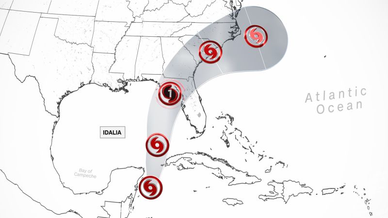
Idalia is projected to make landfall on the morning of Wednesday near Florida’s Big Bend as a Category 2 hurricane. The National Hurricane Center predicts that the storm will strengthen and become a hurricane over the southeastern Gulf of Mexico by Tuesday. Further strengthening is expected as Idalia approaches the northeastern Gulf coast.
The hurricane center has highlighted a “notable risk of rapid intensification” as Idalia moves through the extremely warm waters of the Gulf of Mexico. Such intensification is characterized by a 35 mph increase in sustained winds within a 24-hour period. Idalia is forecasted to bring 3 to 6 inches of rainfall to western Cuba, Florida’s west coast, the Panhandle, and southern Georgia, with isolated areas receiving up to 10 inches.
Flash flooding is a concern, particularly in western Cuba, the west coast of Florida, the Florida Panhandle, and parts of the southeast US. Life-threatening storm surge, heavy rainfall, and hurricane-force winds are anticipated in Florida as early as Tuesday, with the majority of the storm passing over Southeastern areas on Wednesday.
Governor Ron DeSantis of Florida has declared a state of emergency for 33 counties and has activated 1,100 National Guardsmen, granting them access to 2,400 high-water vehicles and 12 aircraft for rescue and recovery operations. The Florida Highway Patrol also has 300 troopers prepared to deploy. Power companies will begin staging personnel on Monday.
Warnings and watches for various regions have been issued, including a tropical storm warning for the Yucatán Peninsula and Pinar del Río in Cuba, a storm surge watch for parts of Florida, a hurricane watch for certain areas of Florida, and a tropical storm watch for other sections of Cuba and Florida.
President Joe Biden has been briefed on the storm and will continue to receive updates as it progresses towards the United States. It is crucial for residents of Mexico’s Yucatán Peninsula, Cuba, and the northern Gulf and Florida coast to closely monitor the forecast in the following days, as the direction and strength of upper-level steering winds will determine the storm’s trajectory and speed.
As the system enters the Gulf of Mexico on Monday, its potential impact on the US will become clearer. The exact strength and speed of the storm are still uncertain, but it will pass through the warmest waters in the Atlantic basin, providing ample energy for development.
Apart from warm water, the system also relies on favorable upper-level winds. High wind shear can disrupt a developing storm, while decreased wind shear in the far northern Caribbean and eastern Gulf of Mexico could allow the system to hold together. Various forecast models suggest different levels of wind shear, affecting the storm’s formation and strength.
In a separate development, Tropical Storm Franklin has intensified into a Category 1 hurricane with maximum sustained winds reaching 90 mph. Hurricane Franklin is currently located south of Bermuda and is moving toward the north-northwest at 8 mph. It is expected to strengthen further and potentially become a major hurricane. Swells generated by Franklin will begin affecting Bermuda, leading to life-threatening surf and rip current conditions along portions of the East Coast of the United States.
Denial of responsibility! VigourTimes is an automatic aggregator of Global media. In each content, the hyperlink to the primary source is specified. All trademarks belong to their rightful owners, and all materials to their authors. For any complaint, please reach us at – [email protected]. We will take necessary action within 24 hours.
