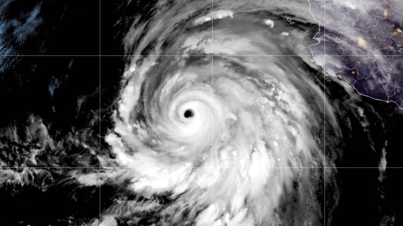
CNN reports that there is growing concern over Hurricane Hilary, as it has the potential to bring unprecedented amounts of rainfall to the southwestern US and parts of California. This has led to the first ever tropical storm watch for California. Hilary may dump more rain than what is typically seen in a year in certain areas of California, Nevada, and Arizona. Consequently, there is a high risk for excessive rainfall in parts of California, which is unprecedented. Hilary is currently a Category 4 hurricane with sustained winds of 130 mph and is expected to remain at this strength as it approaches Mexico’s Baja California peninsula. Hurricane and tropical storm watches and warnings have been issued for Baja California, Los Angeles, and northwest Mexico. The storm’s track will determine where the strongest winds and heaviest rain will occur in the US. Small deviations in the track can significantly impact the forecast. Additionally, the hurricane is moving faster than expected, so Mexico and California will experience impacts sooner than initially predicted. The National Hurricane Center (NHC) forecasts that Hilary will move inland over southern California by Sunday night, with strong winds and heavy rainfall occurring before the hurricane’s center reaches land. While Hilary is more likely to make landfall in Mexico and cross into California, it would be the first tropical storm to make landfall in California in nearly 84 years if it does hit. The NHC issued the first ever tropical storm watch for parts of Southern California. The storm is expected to weaken but will still bring heavy rainfall and increase the risk of flooding. High risks for excessive rainfall are rare but account for the majority of flood-related damage and deaths. Southern parts of California and Nevada could receive 3 to 5 inches of rain, with isolated areas potentially seeing up to 10 inches. Central parts of these states, as well as western Arizona and southwest Utah, are expected to receive 1 to 3 inches of rain. Death Valley, known as the hottest place on Earth, typically receives just 2 inches of rain per year, but Hilary has the potential to bring enough rain to cover 1 to 2 years’ worth of precipitation in a single day. Las Vegas could see 2 to 4 inches of rain, whereas the city usually receives an average of 3.75 inches per year. The prolonged rainfall also poses a threat of overwhelming the ground and waterways, worsening the flood risk. Authorities have closed Mojave National Preserve due to potential flooding and have issued flood watches across Southern California. The National Weather Service has warned of high surf, rip currents, and coastal flooding. Local entities are preparing for the storm and focusing on protecting the homeless population. The Atlantic is also expected to experience an increase in tropical activity, with four separate areas of concern stretching across the basin. The Gulf of Mexico is of particular concern, as it could see tropical development next week. The tropical Atlantic also has three areas of concern, with one potential tropical depression forming near the Cabo Verde Islands and another possible depression forming near the Lesser Antilles.
Denial of responsibility! VigourTimes is an automatic aggregator of Global media. In each content, the hyperlink to the primary source is specified. All trademarks belong to their rightful owners, and all materials to their authors. For any complaint, please reach us at – [email protected]. We will take necessary action within 24 hours.
