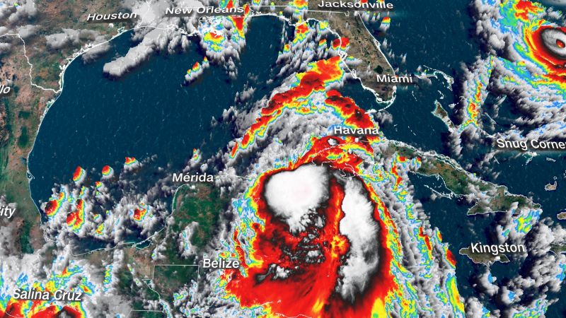
Tropical Storm Idalia is expected to intensify into a powerful Category 3 hurricane on Monday, posing a potential threat to Florida’s Gulf Coast. The storm could bring catastrophic winds, heavy rainfall, and flooding, leading to evacuations and school closures in certain areas of the state. The National Hurricane Center has warned of a life-threatening storm surge for parts of Florida. Currently, Idalia has winds of 70 mph and is located about 10 miles northwest of Cuba’s western tip. Over 8,000 people have been evacuated from the coastal areas of western Cuba. Forecasters predict that Idalia will continue to strengthen and become a major hurricane by late Tuesday before making landfall in Florida on Wednesday. The Big Bend region of Florida, extending from Tampa to just south of Tallahassee, is expected to experience storm surge of up to 12 feet. Mandatory and voluntary evacuations have been issued for multiple counties, including Hillsborough County, which is home to Tampa. The Florida National Guard has activated over 5,000 members to assist with storm response. Mayor Donna Deegan has declared a state of emergency in Jacksonville and opened several shelters for those in need of evacuation. It is important to note that Idalia is forecasted to rapidly intensify from a Category 1 hurricane to a Category 3 hurricane within 24 hours due to warm waters in the Gulf of Mexico. A slight shift in its track could have significant effects on Tampa, bringing stronger winds and a larger storm surge. The impact of Idalia will extend well beyond its projected path, affecting a large portion of Florida’s Gulf Coast. After making landfall, the storm will bring damaging winds and heavy rain to Florida, parts of Georgia, and even the Carolinas. Idalia’s effects will be felt as early as Tuesday, with increasing wind speeds in the Florida Keys and southwestern coast. Gusty winds will spread across a large portion of Florida, including inland areas, by Tuesday night. The worst of the storm’s impact is expected to be in the Tampa area and extend northward through the Big Bend region and into parts of the Panhandle. Conditions will worsen rapidly in these areas as landfall approaches. Storm surge, potentially reaching up to 12 feet, poses a significant threat, particularly in Florida’s Big Bend region. This, coupled with hurricane-force winds exceeding 100 mph, can be extremely dangerous. Storm surge warnings are in effect from Englewood to Indian Pass, including Tampa Bay, indicating the potential for life-threatening rising waters. Evacuation orders have been issued in multiple Florida counties, with the expectation of further orders in low-lying coastal areas and barrier islands. Residents are advised to take evacuation orders seriously, as their safety is at stake. Tampa International Airport will halt commercial operations and plans to reopen after assessing the storm’s impact. An emergency declaration has been expanded to 46 of Florida’s 67 counties, and power companies are deploying personnel in preparation for power outages. The University of Florida and Florida State University have announced campus closures and class cancellations. Schools across the region are also canceling classes ahead of the severe weather. Georgia is also making preparations for Idalia, with Governor Brian Kemp activating the State Operations Center. It is essential to remain vigilant and not underestimate the potential impact of the storm, even if it weakens before reaching Georgia.
Denial of responsibility! VigourTimes is an automatic aggregator of Global media. In each content, the hyperlink to the primary source is specified. All trademarks belong to their rightful owners, and all materials to their authors. For any complaint, please reach us at – [email protected]. We will take necessary action within 24 hours.
