New data has revealed an underground network of “geological hazards” hidden beneath a section of Yellowstone National Park, researchers say. Using lidar technology to map the ground beneath thick forests and dense foliage, scientists have gained insights into an area permanently impacted by prehistoric landslides and major earthquakes. These findings are significant for understanding the potential risks associated with living in the surrounding states, now home to millions of people.
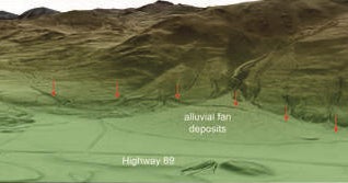
The advanced geological surface mapping, which charts topography in a region and helps to assess the likelihood of earthquakes, volcanic eruptions, and landslides, provided geologists with the clearest view yet of the terrain in Paradise Valley and the vicinity of the northern entrance to Yellowstone. This region normally has obscured ground surfaces because of dense vegetation, but lidar technology has allowed scientists to collect a wealth of data, indicating that the area has been heavily affected by past earthquakes to a greater extent than previously known.
The lidar method, which uses a sensor mounted on an airplane to survey large land areas, is crucial for obtaining accurate data by capturing information about the ground surface and any object along its path. This technology has been instrumental in creating a high-resolution digital model of the bare ground, helping scientists “remove” the vegetation virtually and study the terrain below.
Yellowstone National Park, covering 3,500 square miles, sits on a volcanic hotspot and has aroused significant interest among geologists. Although the probability of a volcanic eruption is deemed unlikely, studying the area is essential due to the likelihood of damaging earthquakes and hydrothermal explosions.
Thanks to discoveries made by “peeling back” dense foliage, geologists have made significant improvements to hazard maps by gaining a better understanding of known faults and landslides. The lidar data has also helped geologists to uncover active faults along the fringes of Yellowstone and led to the identification of detailed fault scarps and prehistoric landslides.
The new information discovered by the Montana Bureau of Mines and Geology is allowing for updated statewide fault and landslide databases to help improve assessments of potentially hazardous conditions in Paradise Valley and northern Yellowstone National Park. It is also contributing to the U.S. Geological Survey National Seismic Hazard Maps.
In the latest developments, the new information is helping to identify a network of fault systems and large prehistoric landslides that have significantly added to the understanding of the area’s geological hazards. These new findings offer valuable insights for future updates in county- and state-wide mitigation efforts to improve public safety in the region.
CBS News journalist Emily Mae Czachor contributed to this report. You can also find her coverage of breaking news, with a focus on crime and extreme weather, in publications such as the Los Angeles Times, BuzzFeed, and Newsweek.
